Inclined Plane
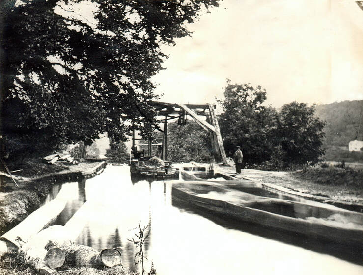
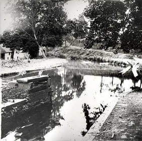
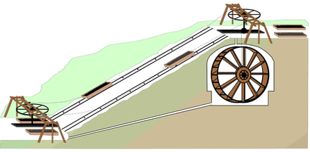
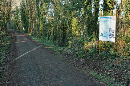
The Inclined Plane at Ridd is where the level of the canal had to be raised 42 feet to the same level as the Torridge upstream of Torrington. Rather than using a series of locks as on larger canals, James Green employed the method he had pioneered on the Bude Canal with an Inclined Plane where the small Tub Boats, which had wheels fitted in their bases, were dragged up a ramp on rails pulled by a chain powered by a water wheel set into an underground chamber at the top. This feature was almost obliterated when the railway was built at a level which cut right through the top of the plane, but part of the soffit of the wheel chamber can still seen in the bank alongside the Tarka Trail.
Why was it built?
Since any length of canal can only run on the level, wherever places at different heights are to be linked some means is required to raise boats from the lower to the higher level, and vice versa, without the water running away in the process. In the case of the Rolle Canal, the river Torridge upstream of Torrington is some 43 ft. higher than the highest tide level where the canal joins the estuary at the Sea Lock, so it was necessary to accommodate this change of level in the building of the canal. It was decided to construct one inclined plane rather than a series of canal locks because in the steep sided Torridge valley, subject to alternate flooding and periods of low flow in the river, this enabled the canal to be sited well above the flood plain, while economising on water usage and improving efficiency of operation.
Since any length of canal can only run on the level, wherever places at different heights are to be linked some means is required to raise boats from the lower to the higher level, and vice versa, without the water running away in the process. In the case of the Rolle Canal, the river Torridge upstream of Torrington is some 43 ft. higher than the highest tide level where the canal joins the estuary at the Sea Lock, so it was necessary to accommodate this change of level in the building of the canal. It was decided to construct one inclined plane rather than a series of canal locks because in the steep sided Torridge valley, subject to alternate flooding and periods of low flow in the river, this enabled the canal to be sited well above the flood plain, while economising on water usage and improving efficiency of operation.
How did it work?
The Rolle Canal was primarily used to transport heavy bulk goods such as coal and limestone upstream and clay for pottery back to the coast. The small heavily built craft used for this purpose were called Tub Boats; they were about 5'6" wide and 20' long and were fitted with iron wheels. These wheels enabled them to run on iron rails that were set into the surface of the inclined plane. There were two sets of rails so that tub boats could be pulled up and lowered down the slope at the same time by a continuous chain running on enormous pulleys at the top and bottom.
The Rolle Canal was primarily used to transport heavy bulk goods such as coal and limestone upstream and clay for pottery back to the coast. The small heavily built craft used for this purpose were called Tub Boats; they were about 5'6" wide and 20' long and were fitted with iron wheels. These wheels enabled them to run on iron rails that were set into the surface of the inclined plane. There were two sets of rails so that tub boats could be pulled up and lowered down the slope at the same time by a continuous chain running on enormous pulleys at the top and bottom.
A tub boat arriving at the foot of the plane would be hooked on to the moving chain which dragged it out of the water and up the slope to the top, where it rolled over the lip into the water of the top basin.
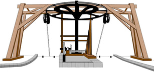
The power to drive the chain that raised the boats up the inclined plane was provided by the water of the canal itself. The water turned a large water-wheel which was built in an underground chamber below the canal basin at the top of the plane, and through some massive gearing the water-wheel turned the shaft that bore the top pulley of the continuous chain running up and down the slope.
The railway that destroyed most of the inclined plane, destroying all the workings of the lifting mechanism, while its embankment obliterated much of the slope of the plane itself. The stone lined chamber which housed the water-wheel and the gearing was filled in with rubble, almost up to the vaulted roof which was part cut away while the rest of it survives under the hedge bank alongside the Tarka Trail which now runs on the railway track.
A then and now video to give you an idea of how much it's changed
Click here to find out a more detailed account of the Inclined Plane at Ridd
More photos of the Inclined Plane HERE